Thursday, November 8, 2007

Snow next week? Maybe!

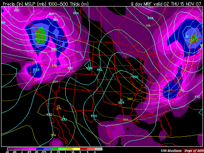
Well...if everyone is enjoying the wild cold weather, you may be in for a treat next week. After having a nice start to the workweek next week, changes may be in the works for mid-week. A shortwave low looks to develop next week and swing right over our region by Wednesday. This strong low will pull down cold air from the north just as it moves over SW Virginia. Below is the image of the 4-panel MRF view for next week, you can click on it to view the larger image:


Now, taking a look at 850mb temps for this time period. There looks to be a window of about 12 hours that 5,000' temps will be below 0°C. Luckily this area is right over SW VA. The forecasting QPF is showing up to .25" of precip, equating to about 2 or three inches of possible snow, but with ground temperatures still above freezing, it likely won't stay around for long, if it does happen. The 540 line is circle around us, but PU/MO counties are right on the edge of the rain-snow line at the surface. This is still a week away, so things can change, as they have over the past 24 hours with this model. I don't expect too much from this system that swings through, but it would be nice to see some snow showers before Thanksgiving break. I'll keep everyone up to date as the week(end) progresses.

Tuesday, November 6, 2007

Possibility of Snow?

The next 10 days look to be interesting for the NRV. Over the next few days, temperatures will be in the upper 40s to around 50. Precipitation looks to stay out of the area for a few days, until around Wednesday, November 14th. What's interesting is this may be a potent system, bringing cold air with it along with the precip. The current MRF model run indicates 850mb temperatures to be below freezing; around -2.0°C, along with the 540 rain-snow line to be located south of our area into Southside, VA. This sets us up with temperatures just above freezing for the event. Here is a look at the forecast date using MRF:

This will have to watched as this model indicates a possibility of 2" of snow for the CWA, but we are over a week away, and any forecasting done this early is definitely going to change over the next few days.

Friday, November 2, 2007

Next week

MRF model still has a cold punch of air coming in for next Wednesday, 7-Nov, but have lengthened the time period a bit.  Now, most of Tuesday may be hard pressed to get out of the 40s, along with Wednesday. 


The 540 line (rain/snow line) looks to set up shop just to our Northwest, along the West Virginia/Virginia border on Tuesday morning, with some light precip falling at that time due to the cold front passage.  850mb temperatures will be below freezing.  Right now, amounts look light, but some of the higher elevations, and westward-facing slopes, may crank out some snow flurries if the precip can stick around with the cold air.  No accumulations though.  Still a few days away though, and this model may change, although the GFS model is a little more conservative, but still brings in the cold air for Tuesday and Wednesday.


Thursday, November 1, 2007

Colder weather is possibly on it's way

Looks like some cooler weather may be on it’s way come next week.  Looking at the 10-day forecast model MRF, high temperatures aren’t expected to get out of the 40s on Wednesday, November 7th.  A cold front looks to move through the area the day before, and high pressure will funnel down colder Canadian air on Wednesday.  I think it’s too early to talk about snow, as it is too warm right now, and this system is still at 6.5 days away…but it won’t be long before we’re talking about the possibility of the first flakes of the season.