
Radar is completely clear of any major precip at the moment, but expecting that to change as we go through the day. Currently it's 47.1° in Snowville with dense fog. Showers will move in from the SW late this morning and into the afternoon/evening timeframe...areas along the Blue Ridge (eastern slopes) will most likely see the heaviest amounts, with SE winds banking up against the mountain range. Latest model guidance at 6z (2AM) indicates around .25" total precip through Sunday afternoon. Expecting the SE winds at 850mb to transport more moisture than this and am going with a total precip amounts of .50" in the NRV with the higher mountains seeing possible .75" to 1-inch in some locations. With the ground already saturated, any t-storms that do form and produce the amounts below within the given timeframe could potential cause some flooding issues.
Flash Flood Guidance for Pulaski County:
1hr: .8"
3hr: 1.4"
12hr: 2.0"
Upper level dynamics will be in place late this afternoon through midday Sunday, with the strongest potential for T-storms SAT evening/night timeframe. If storms do form, isolated areas could see more in the way of precip totals, but deep convection should be limited to the SE US. The SPC has far SW VA and southern & SE VA under a slight risk for severe storms, but not seeing too much potential for this, only for southside and eastern VA.
Precip should be out of the CWA by late on Sunday, but a cold NW flow will develop and could provide the highest elevations with some snow showers with everyone else seeing possibly some flurries....that's right. No accumulations, but a chance of some white precip. Temps will of course be cooler on Sunday into early Monday with highes not getting out of the 40's
We should start to clear skies by Sunday evening into Monday. Temperatures will try to rebound on Monday as our current wx maker moves out of here and to the NE. Upper-level winds will be from the NW, so I'm not expecting too much of a warmup for Monday afternoon.
Tuesday looks to be the warmest day of my 3-day forecast, as a high pressure region funnels warm air into the CWA from the SW. Expect temperatures to warm into the lower 60s for most locations. Another storm system looks to affect our region later next week as it moves in from the Great Plains.
Saturday, March 28, 2009


Monday, March 23, 2009
Monday, March 23, 2009 Forecast
I'm forecasting high's this afternoon for SWVA to be in the mid 60's with abundant sunshine. Winds will be light and from the south with high pressure situated off the SC coast.
Tomorrow looks to be mostly sunny, but slightly cooler with a high around 59. Winds will be light from the W around 5mph.
Expect cooler temps and some precip on Wednesday afternoon with a high around 48. A cold front will move in from the west with rain amounts around .2" by Thursday.
Tomorrow looks to be mostly sunny, but slightly cooler with a high around 59. Winds will be light from the W around 5mph.
Expect cooler temps and some precip on Wednesday afternoon with a high around 48. A cold front will move in from the west with rain amounts around .2" by Thursday.
Wednesday, February 6, 2008
Severe Storms Possible Today
There is a slight risk for severe storms today throughout the CWA and the entire state. The risk is for high winds, but there is a 5% chance of tornadoes just to our west along the WV line and westward. Skywarn may be needed this afternoon in accordance with the Hazardous Weather Outlook statement below:


HAZARDOUS WEATHER OUTLOOK
NATIONAL WEATHER SERVICE BLACKSBURG VA
635 AM EST WED FEB 6 2008

VAZ010>014-016>020-022>024-032>035-071145-
BLAND-GILES-WYTHE-PULASKI-MONTGOMERY-CARROLL-FLOYD-CRAIG-
ALLEGHANY VA-BATH-ROANOKE-BOTETOURT-ROCKBRIDGE-PATRICK-FRANKLIN-
BEDFORD-AMHERST-
635 AM EST WED FEB 6 2008

THIS HAZARDOUS WEATHER OUTLOOK IS FOR CENTRAL VIRGINIA...SOUTH
CENTRAL VIRGINIA...SOUTHWEST VIRGINIA AND WEST CENTRAL VIRGINIA.

.DAY ONE...TODAY AND TONIGHT

ALSO A SLIGHT RISK OF SEVERE THUNDERSTORMS EXISTS TODAY. A STRONG
COLD FRONT WILL BRING SHOWERS AND SCATTERED THUNDERSTORMS TO THE
AREA TODAY. SOME OF THE STORMS WILL BE CAPABLE OF PRODUCING
DAMAGING WINDS.

.DAYS TWO THROUGH SEVEN...THURSDAY THROUGH TUESDAY

VERY STRONG WINDS ARE LIKELY BEHIND A COLD FRONT SATURDAY NIGHT
AND SUNDAY.

.SPOTTER INFORMATION STATEMENT...

SPOTTER ACTIVATION MAY BE NEEDED TODAY.

$$
Thursday, November 8, 2007
Snow next week? Maybe!
Well...if everyone is enjoying the wild cold weather, you may be in for a treat next week. After having a nice start to the workweek next week, changes may be in the works for mid-week. A shortwave low looks to develop next week and swing right over our region by Wednesday. This strong low will pull down cold air from the north just as it moves over SW Virginia. Below is the image of the 4-panel MRF view for next week, you can click on it to view the larger image:


Now, taking a look at 850mb temps for this time period. There looks to be a window of about 12 hours that 5,000' temps will be below 0°C. Luckily this area is right over SW VA. The forecasting QPF is showing up to .25" of precip, equating to about 2 or three inches of possible snow, but with ground temperatures still above freezing, it likely won't stay around for long, if it does happen. The 540 line is circle around us, but PU/MO counties are right on the edge of the rain-snow line at the surface. This is still a week away, so things can change, as they have over the past 24 hours with this model. I don't expect too much from this system that swings through, but it would be nice to see some snow showers before Thanksgiving break. I'll keep everyone up to date as the week(end) progresses.

Now, taking a look at 850mb temps for this time period. There looks to be a window of about 12 hours that 5,000' temps will be below 0°C. Luckily this area is right over SW VA. The forecasting QPF is showing up to .25" of precip, equating to about 2 or three inches of possible snow, but with ground temperatures still above freezing, it likely won't stay around for long, if it does happen. The 540 line is circle around us, but PU/MO counties are right on the edge of the rain-snow line at the surface. This is still a week away, so things can change, as they have over the past 24 hours with this model. I don't expect too much from this system that swings through, but it would be nice to see some snow showers before Thanksgiving break. I'll keep everyone up to date as the week(end) progresses.
Tuesday, November 6, 2007
Possibility of Snow?
The next 10 days look to be interesting for the NRV. Over the next few days, temperatures will be in the upper 40s to around 50. Precipitation looks to stay out of the area for a few days, until around Wednesday, November 14th. What's interesting is this may be a potent system, bringing cold air with it along with the precip. The current MRF model run indicates 850mb temperatures to be below freezing; around -2.0°C, along with the 540 rain-snow line to be located south of our area into Southside, VA. This sets us up with temperatures just above freezing for the event. Here is a look at the forecast date using MRF:
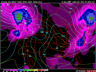
This will have to watched as this model indicates a possibility of 2" of snow for the CWA, but we are over a week away, and any forecasting done this early is definitely going to change over the next few days.

This will have to watched as this model indicates a possibility of 2" of snow for the CWA, but we are over a week away, and any forecasting done this early is definitely going to change over the next few days.
Friday, November 2, 2007
Next week
MRF model still has a cold punch of air coming in for next Wednesday, 7-Nov, but have lengthened the time period a bit. Now, most of Tuesday may be hard pressed to get out of the 40s, along with Wednesday.
The 540 line (rain/snow line) looks to set up shop just to our Northwest, along the West Virginia/Virginia border on Tuesday morning, with some light precip falling at that time due to the cold front passage. 850mb temperatures will be below freezing. Right now, amounts look light, but some of the higher elevations, and westward-facing slopes, may crank out some snow flurries if the precip can stick around with the cold air. No accumulations though. Still a few days away though, and this model may change, although the GFS model is a little more conservative, but still brings in the cold air for Tuesday and Wednesday.
Thursday, November 1, 2007
Colder weather is possibly on it's way
Looks like some cooler weather may be on it’s way come next week. Looking at the 10-day forecast model MRF, high temperatures aren’t expected to get out of the 40s on Wednesday, November 7th. A cold front looks to move through the area the day before, and high pressure will funnel down colder Canadian air on Wednesday. I think it’s too early to talk about snow, as it is too warm right now, and this system is still at 6.5 days away…but it won’t be long before we’re talking about the possibility of the first flakes of the season.
Subscribe to:
Posts (Atom)


 Posts
Posts

